GEOTECHNICAL ENGINEERING
SWANSEA
HomeGeophysicsElectrical resistivity / VES (Vertical Electrical Sounding)

Electrical Resistivity Surveys and Vertical Electrical Sounding in Swansea

Rigorous testing. Clear reporting.

LEARN MORE

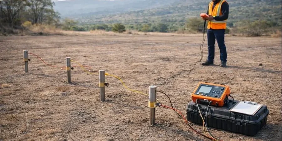
The varied geology beneath Swansea—from the Coal Measures and Pennant Sandstone in the north to the glacial till and estuarine alluvium along the Tawe corridor—makes a single borehole a risky basis for design. We see it often: a site on Kilvey Hill shows competent rock at 2 metres, yet three hundred metres toward the docks the same formation is deeply weathered and water-charged. Electrical resistivity surveying, and specifically Vertical Electrical Sounding (VES), lets us build a continuous profile of these transitions without running a drill rig across every square metre. The method measures how easily the ground passes an injected current; clay, saturated silt, and saline porewater all read quite differently from dry sandstone or intact limestone. For engineers working on piling layouts or footing designs near the waterfront, that contrast is the difference between a straightforward pad and an expensive over-excavation. Our field crews deploy Wenner and Schlumberger arrays calibrated to the urban noise environment typical of a compact city like Swansea, where buried services and tidal fluctuations in the Tawe add complexity that a textbook survey never accounts for.

A well-constrained VES survey in Swansea’s mixed alluvium-and-rock terrain can map a weathered bedrock trough that a grid of boreholes might miss entirely.

Our service areas

Approach and scope

A common mistake on brownfield sites across Swansea is to assume that made ground is electrically homogeneous just because the borehole log describes it as ‘fill.’ Old railway ballast, buried foundations from the former metallurgical works in the Lower Swansea Valley, and pockets of colliery spoil each produce distinct resistivity signatures—and misreading them can place a retaining wall on a hidden soft lens. Our VES protocol runs a multi-electrode spread that steps out incrementally, resolving layer resistivities from near-surface down to 40–60 metres in most local conditions. The data inversion uses a damped least-squares algorithm constrained by any available test pit logs or SPT blow counts, so the geophysical model is tied to physical ground truth. We also cross-check profiles with seismic refraction when the target is top-of-rock beneath variable overburden; the combination gives the engineer both a mechanical stiffness contrast and an electrical stratigraphy that highlights water-bearing zones. On the Gower side, where karstic features in the Carboniferous Limestone can swallow drilling fluid without warning, resistivity imaging often detects air-filled voids before they become a construction crisis.
Electrical Resistivity Surveys and Vertical Electrical Sounding in Swansea
Technical reference — Swansea

Site-specific factors

Swansea’s position on the Bristol Channel introduces a tidal influence that few resistivity practitioners account for properly. The twice-daily fluctuation in porewater salinity within the estuarine muds and tidal flat deposits along the SA1 waterfront can shift apparent resistivity values by more than 30% between low and high water; a survey run without logging the tide stage risks modelling a phantom layer. Further inland, the legacy of shallow coal workings beneath areas like Morriston and Clydach creates a different hazard: flooded mine voids present as extremely low-resistivity zones that can be mistaken for thick clay if the interpreter lacks local mining records. Our approach corrects for saline intrusion using fluid conductivity measurements from on-site water samples, and we reference the Coal Authority’s abandoned mine plan database when processing each profile. For deep basement excavations near the river, where soft-ground tunnelling or cut-and-cover methods are under consideration, this level of detail in the resistivity model can steer the design away from a catastrophic water inflow.

Need a geotechnical assessment?

Reply within 24h.

Email: contact@geotechnical-engineering.biz

Service video


Relevant standards

BS 5930:2015 + A1:2020 (Code of practice for ground investigations), Eurocode 7 – BS EN 1997-2:2007 (Ground investigation and testing), ASTM D6431-18 (Standard Guide for Using the DC Resistivity Method), BS 8574:2014 (Code of practice for ground investigations – geophysical techniques)

Technical parameters

ParameterTypical value
Array configurationsWenner, Schlumberger, dipole-dipole (site-dependent)
Typical investigation depth1 to 60 m below ground level
Electrode spacing range1 m to 150 m maximum spread length
Data inversion methodDamped least-squares with L1/L2 norm options
Output1D sounding curves and 2D resistivity tomograms
Quality assuranceReciprocity checks and repeat station measurements
Reporting standardBS 5930:2015 + A1:2020, Eurocode 7 (BS EN 1997-2)
Applicable ground conditionsMade ground, alluvium, glacial till, sandstone, limestone

Q&A

How much does an electrical resistivity survey typically cost for a site in Swansea?

For a standalone VES campaign or a short 2D resistivity line on a residential-scale plot in the Swansea area, budgets generally fall between £450 and £900 plus VAT, depending on the number of soundings, the line length, and the access conditions. A larger commercial site requiring multiple ERT profiles, cross-hole tomography, or combined geophysics will sit above that range. We provide a fixed-price proposal once we review the desk study and the site layout.

Can resistivity testing identify old mine workings beneath a site in Swansea?

Yes, with the important caveat that it must be interpreted alongside mining records. Air-filled voids in the Pennant Sandstone or the Middle Coal Measures appear as high-resistivity anomalies, while flooded workings show a sharp drop in resistivity. We cross-reference every anomaly with the Coal Authority’s abandoned mine plan database and, where possible, tie the geophysical signature to rotary borehole data to confirm whether a feature is a void, a collapsed zone, or a lithological change.

How long does a VES survey take on a typical Swansea site, and what access is needed?

A single Vertical Electrical Sounding with a full electrode spread out to 100–150 metres takes about 45–60 minutes to set up and measure, provided the ground is reasonably open. A 2D tomography line of 200 metres may take half a day with a two-person crew. We need pedestrian access for electrode placement and a clear corridor roughly the width of a footpath; the equipment is lightweight and causes no surface damage, so it works well on soft landscaping and even within existing car parks or school grounds during quiet periods.

Location and service area

We serve projects across Swansea and its metropolitan area.

View larger map